UAV-VLA: Vision-Language-Action System for Large Scale Aerial Mission Generation

This repository is for the research paper accepted in Proc. ACM/IEEE Int. Conf. on Human Robot Interaction (HRI 2025)
Table of Contents
- Abstract
- Benchmark
- Installation
- Mission Generation
- Path-Plans Creation
- Experimental Results
- Simulation Video
- Citation
Abstract
The UAV-VLA (Visual-Language-Action) system is a tool designed to facilitate communication with aerial robots. By integrating satellite imagery processing with Gemini multimodal models, UAV-VLA enables users to generate general flight paths-and-action plans through simple text requests. This system leverages the rich contextual information provided by satellite images, allowing for enhanced decision-making and mission planning. The current implementation uses Gemini both for visual object localization on satellite images and for natural-language mission generation. The original benchmark results showed the difference in the length of the created trajectory in 22% and the mean error in finding the objects of interest on a map in 34.22 m by Euclidean distance in the K-Nearest Neighbors (KNN) approach.
https://arxiv.org/abs/2501.05014
This repository includes:
- The implementation of the UAV-VLA framework.
- Dataset and benchmark details.
- Archived code and artifacts for simulation-based experiments in Mission Planner.
UAV-VLA Framework
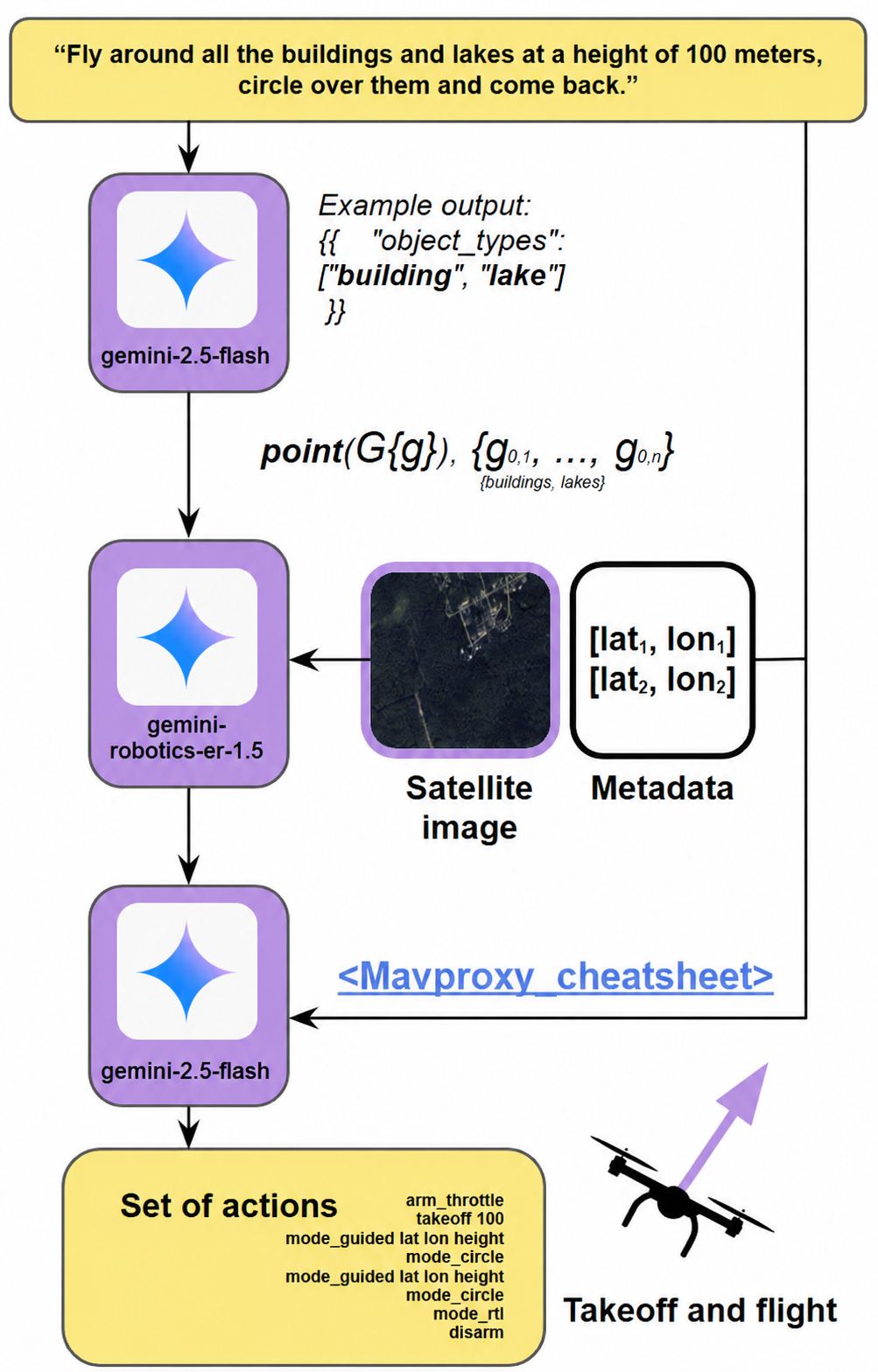
Benchmark
The images of the benchmark are stored in the folder benchmark-UAV-VLPA-nano-30/images. The metadata file used by the current pipeline is benchmark-UAV-VLPA-nano-30/parsed_coordinates.csv, which stores image corner coordinates for converting image-percentage points to latitude/longitude.
Additional historical Mission Planner and experiment files are stored in archive/.
Installation
To install requirements, run
pip install -r requirements.txt
The current Gemini-based pipeline runs through an API and does not require a local GPU. The archived Molmo-based legacy pipeline required a CUDA GPU with substantial VRAM.
Export your Gemini API key
export GEMINI_API_KEY="your gemini api_key"
Alternatively, create a local .env file in the repository root:
GEMINI_API_KEY="your gemini api_key"
GEMINI_MODEL="gemini-2.5-flash"
NUMBER_OF_SAMPLES=30
GEMINI_MAX_RETRIES=5
GEMINI_RETRY_DELAY_SECONDS=10
GEMINI_SAMPLE_DELAY_SECONDS=5
Mission generation
To generate commands for UAV, add your Gemini API key to the environment or to a local .env file, then run:
python3 generate_plans.py
The script will:
- extract building-like object types from the mission command;
- send benchmark satellite images to Gemini Vision for object localization;
- convert Gemini image-percentage coordinates to latitude/longitude;
- save annotated images to
identified_new_data/; - generate mission command files in
created_missions/.
To run the full pipeline for only one image, pass the image filename:
python3 generate_plans.py 1.jpg
Path-Plans Creation
The current path-plan creation is part of generate_plans.py. It produces pseudo-language UAV mission files in created_missions/, for example:
arm throttle
takeoff 100
mode guided 42.87946931666667 -85.4114592638889 100
mode circle
mode rtl
disarm
The old local Molmo VLM runner has been moved to archive/legacy_molmo/.
Some examples of the path generated can be seen below:
Experimental Results
The original experimental pipeline and generated artifacts are stored in archive/experiments/. This code was used to compare VLM-generated coordinates with Mission Planner data, calculate trajectory lengths, calculate RMSE metrics, and produce visualizations.
If you want to inspect or rerun the archived experiment code, navigate into the folder archive/experiments/, then run:
python3 main.py
Note: the archived experiment runner expects the historical VLM output file identified_points.txt. The current Gemini pipeline does not generate that file by default; it writes annotated images to identified_new_data/ and missions to created_missions/.
What Happens When You run main.py:
-
Generate Home Positions
-
Generate VLM Coordinates
-
Generate MP Coordinates
-
Calculate Trajectory Lengths
-
Calculate RMSE (Root Mean Square Error)
-
Plot Results
-
Generate Identified Images: The script generates images by overlaying the VLM and Mission Planner (human-generated) coordinates on the original images from the dataset. These identified images are saved in
archive/experiments/identified_images_VLM/(for VLM outputs) andarchive/identified_images_mp/(for Mission Planner outputs).
After running the script, you will be able to examine:
- Text Files: Containing the generated coordinates, home positions, and RMSE data.
- Images: Showing the identified coordinates overlaid on the images.
- Plots: Comparing trajectory lengths and RMSE values.
Trajectory Bar Chart:
Error Box Plot:
Error Comparison Table:
The errors were calculated using different approaches including K-Nearest Neighbor (KNN), Dynamic Time Warping (DTW), and Linear Interpolation.
| # | Metric | KNN Error (m) | DTW RMSE (m) | Interpolation RMSE (m) |
|---|---|---|---|---|
| 1 | Mean | 45.91 | 291.94 | 403.03 |
| 2 | Median | 30.26 | 279.58 | 376.55 |
| 3 | Max | 299.04 | 711.40 | 738.07 |
Simulation Video
The generated mission from the UAV-VLA framework was tested in the ArduPilot Mission Planner. The simulation can be seen below.
https://github.com/user-attachments/assets/562f2ee7-13e5-44a0-bb0f-6c109a958123
Citation
@inproceedings{10.5555/3721488.3721725,
author = {Sautenkov, Oleg and Yaqoot, Yasheerah and Lykov, Artem and Mustafa, Muhammad Ahsan and Tadevosyan, Grik and Akhmetkazy, Aibek and Altamirano Cabrera, Miguel and Martynov, Mikhail and Karaf, Sausar and Tsetserukou, Dzmitry},
title = {UAV-VLA: Vision-Language-Action System for Large Scale Aerial Mission Generation},
year = {2025},
publisher = {IEEE Press},
abstract = {The UAV-VLA (Visual-Language-Action) system is a tool designed to facilitate communication with aerial robots. By integrating satellite imagery processing with the Visual Language Model (VLM) and the powerful capabilities of GPT, UAV-VLA enables users to generate general flight paths-and-action plans through simple text requests. This system leverages the rich contextual information provided by satellite images, allowing for enhanced decision-making and mission planning. The combination of visual analysis by VLM and natural language processing by GPT can provide the user with the path-and-action set, making aerial operations more efficient and accessible. The newly developed method showed the difference in the length of the created trajectory in 22\% and the mean error in finding the objects of interest on a map in 34.22 m by Euclidean distance in the K-Nearest Neighbors (KNN) approach. Additionally, the UAV-VLA system generates all flight plans in just 5 minutes and 24 seconds, making it 6.5 times faster than an experienced human operator.},
booktitle = {Proceedings of the 2025 ACM/IEEE International Conference on Human-Robot Interaction},
pages = {1588–1592},
numpages = {5},
keywords = {drone, llm-agents, navigation, path planning, uav, vla, vlm, vlm-agents},
location = {Melbourne, Australia},
series = {HRI '25}
}